Mercury was named by the Romans after the fleet-footed messenger of the gods because it seemed to move more quickly than any other
planet. It is the closest planet to the Sun, and second smallest planet in the solar system. Its diameter is 40% smaller than Earth and 40% larger than the Moon. It is even smaller than Jupiter's moon Ganymede and Saturn's moon Titan.
If an explorer were to step onto the surface of Mercury, he would discover a world resembling lunar terrain. Mercury's
rolling, dust-covered hills have been eroded from the constant bombardment of meteorites. Fault-cliffs rise for several kilometers in height and extend for hundreds of kilometers. Craters dot the surface. The explorer
would notice that the Sun appears two and a half times larger than on Earth; however, the sky is always black because Mercury
has virtually no atmosphere to cause scattering of light. As the explorer gazes out into space, he might see two bright stars.
One appearing as cream colored Venus and the other as blue colored Earth.
Until Mariner 10, little was known about Mercury because of the difficulty in observing it from Earth telescopes. At maximum elongation it
is only 28 degrees from the Sun as seen from Earth. Because of this, it can only be viewed during daylight hours or just prior
to sunrise or after sunset. When observed at dawn or dusk, Mercury is so low on the horizon that the light must pass through
10 times the amount of Earth's atmosphere than it would if Mercury was directly overhead.
During the 1880's, Giovanni Schiaparelli drew a sketch showing faint features on Mercury. He determined that Mercury must
be tidally locked to the Sun, just as the Moon is tidally locked to Earth. In 1962, radio astronomers looked at radio emissions
from Mercury and determined that the dark side was too warm to be tidally locked. It was expected to be much colder if it
always faced away from the Sun. In 1965, Pettengill and Dyce determined Mercury's period of rotation to be 59 +- 5 days based
upon radar observations. Later in 1971, Goldstein refined the rotation period to be 58.65 +- 0.25 days using radar observations.
After close observation by the Mariner 10 spacecraft, the period was determined to be 58.646 +- 0.005 days.
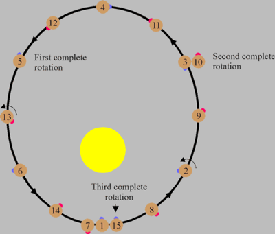
Although Mercury is not tidally locked to the Sun, its rotational period is tidally coupled to its orbital period. Mercury
rotates one and a half times during each orbit. Because of this 3:2 resonance, a day on Mercury (sun rise to sun rise) is
176 Earth days long as shown by the following diagram.
During Mercury's distant past, its period of rotation may have been faster. Scientists speculate that its rotation could
have been as rapid as 8 hours, but over millions of years it was slowly despun by solar tides. A model of this process shows
that such a despinning would take 109 years and would have raised the interior temperature by 100 degrees Kelvin.
Most of the scientific findings about Mercury comes from the Mariner 10 spacecraft which was launched on November 3, 1973. It flew past the planet on March 29, 1974 at a distance of 705 kilometers
from the surface. On September 21, 1974 it flew past Mercury for the second time and on March 16, 1975 for the third time.
During these visits, over 2,700 pictures were taken, covering 45% of Mercury's surface. Up until this time, scientists did
not suspect that Mercury would have a magnetic field. They thought that because Mercury is small, its core would have solidified long ago. The presence of a magnetic field indicates
that a planet has an iron core that is at least partially molten. Magnetic fields are generated from the rotation of a conductive
molten core and is known as the dynamo effect.
Mariner 10 showed that Mercury has a magnetic field that is 1% as strong as Earth's. This magnet field is inclined 7 degrees
to Mercury's axis of rotation and produces a magnetosphere around the planet. The source of the magnetic field is unknown. It might be produced from a partially molten iron core in
the planet's interior. Another source of the field might be from remnant magnetization of iron-bearing rocks which were magnetized
when the planet had a strong magnetic field during its younger years. As the planet cooled and solidified remnant magnetization
was retained.
Even before Mariner 10, Mercury was known to have a high density. Its density is 5.44 g/cm3 which is comparable to Earth's 5.52g/cm3 density. In an uncompressed state,
Mercury's density is 5.5 g/cm3 where Earth's is only 4.0 g/cm3. This high density indicates that the
planet is 60 to 70 percent by weight metal, and 30 percent by weight silicate. This gives a core radius of 75% of the planet
radius and a core volume of 42% of the planet's volume.
Surface of Mercury
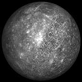
The pictures returned from the Mariner 10 spacecraft showed a world that resembles the moon. It is pocked with craters,
contains hugh multi-ring basins, and many lava flows. The craters range in size from 100 meters (the smallest resolvable feature
on Mariner 10 images) to 1,300 kilometers. They are in various stages of preservation. Some are young with sharp rims and
bright rays extending from them. Others are highly degraded, with rims that have been smoothed from the bombardment of meteorites.
The largest crater on Mercury is the Caloris basin. A basin was defined by Hartmann and Kuiper (1962) as a "large circular depression with distinctive concentric rings and
radial lineaments." Others consider any crater larger than 200 kilometers a basin. The Caloris basin is 1,300 kilometers in
diameter, and was probably caused by a projectile larger than 100 kilometers in size. The impact produced concentric mountain
rings three kilometers high and sent ejecta 600 to 800 kilometers across the planet. (Another good example of a basin showing
concentric rings is the Valhalla region on Jupiter's moon Callisto.) The seismic waves produced from the Caloris impact focused onto the other side of the planet and produced a region of chaotic
terrain. After the impact the crater was partially filled with lava flows.
Mercury is marked with great curved cliffs or lobate scarps that were apparently formed as Mercury cooled and shrank a
few kilometers in size. This shrinking produced a wrinkled crust with scarps kilometers high and hundreds of kilometers long.
The majority of Mercury's surface is covered by plains. Much of it is old and heavily cratered, but some of the plains
are less heavily cratered. Scientists have classified these plains as intercrater plains and smooth plains. Intercrater plains
are less saturated with craters and the craters are less than 15 kilometers in diameter. These plains were probably formed
as lava flows buried the older terrain. The smooth plains are younger still with fewer craters. Smooth plains can be found
around the Caloris basin. In some areas patches of smooth lava can be seen filling craters.
Mercury's history of formation is similar to that of Earth's. About 4.5 billion years ago the planets formed. This was
a time of intense bombardment for the planets as they scooped up matter and debris left around from the nebula that formed
them. Early during this formation, Mercury probably differentiated into a dense metallic core, and a silicate crust. After
the intense bombardment period, lava flowed across the surface and covered the older crust. By this time much of the debris
had been swept up and Mercury entered a lighter bombardment period. During this period the intercrater plains formed. Then
Mercury cooled. Its core contracted which in turn broke the crust and produced the prominent lobate scarps. During the third
stage, lava flooded the lowlands and produced the smooth plains. During the fourth stage micrometeorite bombardment created
a dusty surface also known as regolith. A few larger meteorites impacted the surface and left bright rayed craters. Other
than the occasional collisions of a meteorites, Mercury's surface is no longer active and remains the same as it has for millions
of years.
Could water exist on Mercury?
It would appear that Mercury could not support water in any form. It has very little atmosphere and is blazing hot during
the day, but in 1991 scientists at Caltech bounced radio waves off Mercury and found an unusual bright return from the north
pole. The apparent brightening at the north pole could be explained by ice on or just under the surface. But is it possible
for Mercury to have ice? Because Mercury's rotation is almost perpendicular to its orbital plain, the north pole always sees
the sun just above the horizon. The insides of craters would never be exposed to the Sun and scientists suspect that they
would remain colder than -161 C. These freezing temperatures could trap water outgassed from the planet, or ices brought to
the planet from cometary impacts. These ice deposits might be covered with a layer of dust and would still show bright radar
returns.
| Mercury Statistics |
| Mass (kg) |
3.303e+23 |
| Mass (Earth = 1) |
5.5271e-02 |
| Equatorial radius (km) |
2,439.7 |
| Equatorial radius (Earth = 1) |
3.8252e-01 |
| Mean density (gm/cm^3) |
5.42 |
| Mean distance from the Sun (km) |
57,910,000 |
| Mean distance from the Sun (Earth = 1) |
0.3871 |
| Rotational period (days) |
58.6462 |
| Orbital period (days) |
87.969 |
| Mean orbital velocity (km/sec) |
47.88 |
| Orbital eccentricity |
0.2056 |
| Tilt of axis (degrees) |
0.00 |
| Orbital inclination (degrees) |
7.004 |
| Equatorial surface gravity (m/sec^2) |
2.78 |
| Equatorial escape velocity (km/sec) |
4.25 |
| Visual geometric albedo |
0.10 |
| Magnitude (Vo) |
-1.9 |
| Mean surface temperature |
179°C |
| Maximum surface temperature |
427°C |
| Minimum surface temperature |
-173°C |
| Atmospheric composition
Helium
Sodium
Oxygen
Other |
42%
42%
15%
1% |
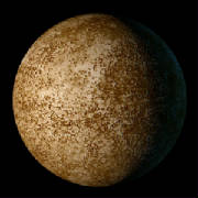
 Mercury Globe
This is a projected image of Mercury using a cylindrical map created by Steve Albers' based on mosaics of the planet
produced by Mark S. Robinson. Additional editing and touch up was done by Calvin J. Hamilton. (Copyright Calvin J. Hamilton)
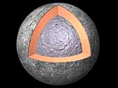 The Interior of Mercury
Most of what is known about the internal structure of Mercury comes from data acquired by the Mariner 10 spacecraft that
flew past the planet in 1973 and 1974. Mercury is about a third of the size of Earth, yet its density is comparable to that
of Earth. This indicates that Mercury has a large core roughly the size of Earth's moon or about 75% of the planet's radius.
The core is likely composed of 60 to 70% iron by mass. Mariner 10's measurements of the planet reveals a dipolar magnetic
field possibly produced by a partially molten core. A solid rocky mantle surrounds the core with a thin crust of about 100
kilometers. (Copyright Calvin J. Hamilton)
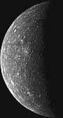 Incoming View of Mercury
This photomosaic of Mercury was constructed from photos taken by Mariner 10 six hours before the spacecraft flew past the planet on March 29, 1974. These images were taken from a distance of 5,380,000
kilometers (3,340,000 miles). (Courtesy USGS, and NASA)
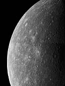 Mercury
This two image (FDS 26850, 26856) mosaic of Mercury was constructed from photos taken by Mariner 10 a few hours before the spacecraft's closest and first encounter with the planet on March 29, 1974. (Copyright Calvin J.
Hamilton)
 Outgoing View of Mercury
This mosaic of Mercury was created from more than 140 images taken by the Mariner 10 spacecraft as it flew past the innermost
planet on March 29, 1974. Mariner 10's trajectory brought the spacecraft across the dark hemisphere of Mercury. The images
were acquired after the spacecraft exited Mercury's shadow. (Courtesy Mark Robinson, Northwestern University)
 Hills of Mercury
"Weird terrain" best describes this hilly, lineated region of Mercury. This area is at the antipodal point from the large Caloris basin. The shock wave produced by the Caloris impact was reflected and focused to this antipodal
point, thus jumbling the crust and breaking it into a series of complex blocks. The area covered is about 100 kilometers (62
miles) on a side. (Copyright Calvin J. Hamilton; FDS 27370)
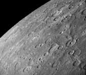
 Southwest Mercury
This image is a portion of the southwest quadrant of Mercury taken March 29, 1974, by the Mariner 10 spacecraft. The picture was taken four hours before the time of closest approach when Mariner was 198,000 kilometers (123,000
miles) from the planet. The largest craters seen in this picture are about 100 kilometers (62 miles) in diameter. (Copyright
Calvin J. Hamilton; FDS 27216, 27217, 27224, 27225)
 Caloris Basin
This mosaic shows the Caloris Basin (located half-way in shadow on the morning terminator). Caloris is Latin for heat
and the basin is named this because it is near the subsolar point (the point closest to the sun) when Mercury is at aphelion. Caloris basin is 1,300 kilometers (800 miles) in diameter and is the largest know structure on Mercury. It was formed from
an impact of a projectile with asteroid dimensions. The interior floor of the basin contains smooth plains but is highly ridged
and fractured. North is towards the top of this image. (Copyright Calvin J. Hamilton; FDS 188-199)
 Caloris Basin Floor
This image is a high resolution view of the Caloris Basin shown in the previous image. It shows ridges and fractures
that increase in size towards the center of the basin (upper left). (Copyright Calvin J. Hamilton; FDS 126)
 Bright Rayed Craters
This image shows two prominent craters (upper right) with bright halos on Mercury. The craters are about 40 kilometers
(25 miles) in diameter. The halos and rays cover other features on the surface indicating that they are some of the youngest
on Mercury. (Copyright Calvin J. Hamilton; FDS 275)
 Double Ring Basin
This image shows a double-ring basin which is 200 kilometers (120 miles) in diameter. The floor contains smooth plains
material. The inner ring basin is at a lower elevation than the outer ring. (Copyright Calvin J. Hamilton; FDS 27301)
 Large Faults on Mercury
This Mariner 10 image shows Santa Maria Rupes, the sinuous dark feature running through the crater at the center of this image. Many such features were discovered in the
Mariner images of Mercury and are interpreted to be enormous thrust faults where part of the mercurian crust was pushed slightly over an adjacent part by compressional forces. The abundance and length
of the thrust faults indicate that the radius of Mercury decreased by 1-2 kilometers (.6 - 1.2 miles) after the solidification
and impact cratering of the surface. This volume change probably was due to the cooling of the planet, following the formation
of a metallic core three-fourths the size of the planet. North is towards the top and is 200 kilometers (120 miles) across.
(© Copyright 1998 by Calvin J. Hamilton; FDS 27448)
 Antoniadi Ridge
This is an image of a 450 kilometer (280 mile) ridge called Antoniadi. It travels along the right edge of the image,
and transects a large 80 kilometer (50 mile) crater about half way in between. It crosses smooth plains to the north and intercrater
plains to the south [Strom et al., 1975]. (Copyright Calvin J. Hamilton)