Mars is the fourth planet from the Sun and is commonly referred to as the Red Planet. The rocks, soil and sky have a red
or pink hue. The distinct red color was observed by stargazers throughout history. It was given its name by the Romans in
honor of their god of war. Other civilizations have had similar names. The ancient Egyptians named the planet Her Descher
meaning the red one.
Before space exploration, Mars was considered the best candidate for harboring extraterrestrial life. Astronomers thought
they saw straight lines crisscrossing its surface. This led to the popular belief that irrigation canals on the planet had
been constructed by intelligent beings. In 1938, when Orson Welles broadcasted a radio drama based on the science fiction
classic War of the Worlds by H.G. Wells, enough people believed in the tale of invading Martians to cause a near panic.
Another reason for scientists to expect life on Mars had to do with the apparent seasonal color changes on the planet's
surface. This phenomenon led to speculation that conditions might support a bloom of Martian vegetation during the warmer
months and cause plant life to become dormant during colder periods.
In July of 1965, Mariner 4, transmitted 22 close-up pictures of Mars. All that was revealed was a surface containing many craters and naturally occurring
channels but no evidence of artificial canals or flowing water. Finally, in July and September 1976, Viking Landers 1 and 2 touched down on the surface of Mars. The three biology experiments aboard the landers discovered unexpected
and enigmatic chemical activity in the Martian soil, but provided no clear evidence for the presence of living microorganisms
in the soil near the landing sites. According to mission biologists, Mars is self-sterilizing. They believe the combination
of solar ultraviolet radiation that saturates the surface, the extreme dryness of the soil and the oxidizing nature of the soil chemistry prevent the formation
of living organisms in the Martian soil. The question of life on Mars at some time in the distant past remains open.
Other instruments found no sign of organic chemistry at either landing site, but they did provide a precise and definitive
analysis of the composition of the Martian atmosphere and found previously undetected trace elements.
Atmosphere
The atmosphere of Mars is quite different from that of Earth. It is composed primarily of carbon dioxide with small amounts
of other gases. The six most common components of the atmosphere are:
- Carbon Dioxide (CO2): 95.32%
- Nitrogen (N2): 2.7%
- Argon (Ar): 1.6%
- Oxygen (O2): 0.13%
- Water (H2O): 0.03%
- Neon (Ne): 0.00025 %
Martian air contains only about 1/1,000 as much water as our air, but even this small amount can condense out, forming
clouds that ride high in the atmosphere or swirl around the slopes of towering volcanoes. Local patches of early morning fog
can form in valleys. At the Viking Lander 2 site, a thin layer of water frost covered the ground each winter.
There is evidence that in the past a denser martian atmosphere may have allowed water to flow on the planet. Physical features
closely resembling shorelines, gorges, riverbeds and islands suggest that great rivers once marked the planet.
Temperature and Pressure
The average recorded temperature on Mars is -63° C (-81° F) with a maximum temperature of 20° C (68° F) and a minimum of
-140° C (-220° F).
Barometric pressure varies at each landing site on a semiannual basis. Carbon dioxide, the major constituent of the atmosphere,
freezes out to form an immense polar cap, alternately at each pole. The carbon dioxide forms a great cover of snow and then
evaporates again with the coming of spring in each hemisphere. When the southern cap was largest, the mean daily pressure
observed by Viking Lander 1 was as low as 6.8 millibars; at other times of the year it was as high as 9.0 millibars. The pressures
at the Viking Lander 2 site were 7.3 and 10.8 millibars. In comparison, the average pressure of the Earth is 1000 millibars.
| Mars Statistics |
| Mass (kg) |
6.421e+23 |
| Mass (Earth = 1) |
1.0745e-01 |
| Equatorial radius (km) |
3,397.2 |
| Equatorial radius (Earth = 1) |
5.3264e-01 |
| Mean density (gm/cm^3) |
3.94 |
| Mean distance from the Sun (km) |
227,940,000 |
| Mean distance from the Sun (Earth = 1) |
1.5237 |
| Rotational period (hours) |
24.6229 |
| Rotational period (days) |
1.025957 |
| Orbital period (days) |
686.98 |
| Mean orbital velocity (km/sec) |
24.13 |
| Orbital eccentricity |
0.0934 |
| Tilt of axis (degrees) |
25.19 |
| Orbital inclination (degrees) |
1.850 |
| Equatorial surface gravity (m/sec^2) |
3.72 |
| Equatorial escape velocity (km/sec) |
5.02 |
| Visual geometric albedo |
0.15 |
| Magnitude (Vo) |
-2.01 |
| Minimum surface temperature |
-140°C |
| Mean surface temperature |
-63°C |
| Maximum surface temperature |
20°C |
| Atmospheric pressure (bars) |
0.007 |
| Atmospheric composition
Carbon Dioxide (C02)
Nitrogen (N2)
Argon (Ar)
Oxygen (O2)
Carbon Monoxide
(CO)
Water (H2O)
Neon (Ne)
Krypton (Kr)
Xenon (Xe)
Ozone (O3) |
95.32%
2.7%
1.6%
0.13%
0.07%
0.03%
0.00025%
0.00003%
0.000008%
0.000003% |
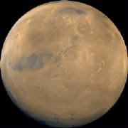
 Mars With Cloud Cover
This image of mars came from a series of pictures taken by the Mars Global Surveyor wide angle cameras. A map was created
and then wrapped around a sphere to generate this view of Mars. Here, bluish-white water ice clouds hang above the Tharsis
volcanoes. (Copyright 2005 by Calvin J. Hamilton)
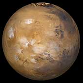
 Large Mosaic of Mars
This image is a large mosaic of the Valles Marineris [VAL-less mar-uh-NAIR-iss] hemisphere of Mars. It is a view similar
to that which one would see from a spacecraft. The lower center of the scene shows the entire Valles Marineris canyon system,
more than 3,000 kilometers (1,860 miles) long and up to 8 kilometers (5 miles) deep, extending from Noctis Labyrinthus, the
arcuate system of graben to the west, to the chaotic terrain to the east. Many huge ancient river channels begin from the
chaotic terrain and north-central canyons and run north. Many of the channels flowed into a basin called Acidalia Planitia,
which is the dark area in the extreme north of this picture. The three Tharsis volcanoes (dark red spots), each about 25 kilometers
(16 miles) high, are visible to the west along with Olympus Mons the largest volcano on the planet. Very ancient terrain covered
by many impact craters lies to the south of Valles Marineris. The polar cap can be seen to the north. (Copyright Calvin
J. Hamilton)
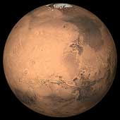
 The Interior of Mars
The current understanding of the interior of Mars suggests that it can be modeled with a thin crust, similar to Earth's,
a mantle and a core. Using four parameters, the Martian core size and mass can be determined. However, only three out of the
four are known and include the total mass, size of Mars, and the moment of inertia. Mass and size was determined accurately
from early missions. The moment of inertia was determined from Viking lander and Pathfinder Doppler data, by measuring the
precession rate of Mars. The fourth parameter, needed to complete the interior model, will be obtained from future spacecraft
missions. With the three known parameters, the model is significantly constrained. If the Martian core is dense (composed
of iron) similar to Earth's or SNC meteorites thought to originate from Mars, then the minimum core radius would be about
1300 kilometers. If the core is made out of less-dense material such as a mixture of sulfur and iron, the maximum radius would
probably be less than 2000 kilometers. (Copyright 1998 by Calvin J. Hamilton)
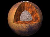
 Topography Map of Mars
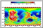
This image is a newly released topographic map of Mars. The full range of topography on Mars is about 19 miles (30 kilometers),
one and a half times the range of elevations found on Earth, The most curious aspect of the map is the striking difference
between the planet's low, smooth Northern Hemisphere and the heavily cratered Southern Hemisphere," which sits, on average,
about three miles (five kilometers) higher than the north. (Courtesy GSFC/NASA)
 Schiaparelli Hemisphere
This image is a mosaic of the Schiaparelli hemisphere of Mars. The center of this image is near the impact crater Schiaparelli,
450 kilometers (280 miles) in diameter. The dark streaks with bright margins emanating from craters in the Oxie Palus region,
upper left of image, are caused by erosion and/or deposition by the wind. Bright white areas to the south, including the Hellas
impact basin at extreme lower right, are covered by carbon dioxide frost. (Courtesy USGS)
 Central Candor Chasm - Oblique View
This image shows part of Candor Chasm in Valles Marineris. It is centered at Latitude -5.0, Longitude 70.0. The view
is from the north looking into the chasm. Candor Chasm's geomorphology is complex, shaped by tectonics, mass wasting, wind,
and perhaps by water and volcanism. (Courtesy USGS)
 West Candor Chasm (Enhanced Color)
This picture (centered at latitude 4° S, longitude 76° W) shows areas of central Valles Marineris, including Candor Chasm
(lower left), Ophir Chasm (lower right), and Hebes Chasm (upper right). Complex layered deposits in the canyons may have been
deposited in lakes, and if so, are of great interest for future searches for fossil life on Mars. The pinkish deposits in
Candor Chasm may be due to hydrothermal alterations and the production of crystalline ferric oxides. ((Geissler et al.,
1993, Icarus 106,380). Viking Orbiter Picture Numbers 279B02 (violet), 279B10 (green), and 279B12 (red) at 240 meters/pixel
resolution. Picture width is 231 kilometers. North is 47° clockwise from top.)
 Ophir Chasma
Ophir Chasma is a large west-northwest-trending trough about 100 km wide. The Chasma is bordered by 4 km high walled
cliffs, most likely faults, that show spur-and-gully morphology and smooth sections. The walls have been dissected by landslides
forming reentrants; one area (upper left) on the north wall shows a young landslide about 100 km wide. The volume of the landslide
debris is more than 1000 times greater than that from the May 18, 1980 debris avalanche from Mount St. Helens. The longitudinal
grooves seen in the foreground are thought to be due to differential shear and lateral spreading at high velocities. The landslide
passes between mounds of interior layered deposits on the floor of the chasma. (Courtesy USGS)
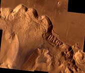
 Landslide in Valles Marineris
Although Valles Marineris originated as a tectonic structure, it has been modified
by other processes. This image shows a close-up view of a landslide on the south wall of Valles Marineris. This landslide
partially removed the rim of the crater that is on the plateau adjacent to Valles Marineris. Note the texture of the landslide
deposit where it flowed across the floor of Valles Marineris. Several distinct layers can be seen in the walls of the trough.
These layers may be regions of distinct chemical composition or mechanical properties in the Martian crust. (Copyright
Calvin J. Hamilton; Caption: LPI)
 HST 3 Views of Mars at Opposition
These Hubble Space Telescope views provide the most detailed complete global
coverage of the Red Planet ever seen from Earth. The pictures were taken on February 25, 1995, when Mars was at a distance
of 103 million kilometers (65 million miles). To the surprise of researchers, Mars is cloudier than seen in previous years.
This means the planet is cooler and drier, because water vapor in the atmosphere freezes out to form ice-crystal clouds. The
three images show the Tharsis, Valles Marineris and Syrtis Major regions. (Credit: Philip James, University of Toledo;
Steven Lee, University of Colorado; and NASA)
 Outflow Source of Channel Ravi Vallis
This image of the head of Ravi Vallis shows a 300-kilometer (186-mile) long
portion of a channel. Like many other channels that empty into the northern plains of Mars, Ravi Vallis orginates in a region
of collapsed and disrupted ("chaotic") terrain within the planet's older, cratered highlands. Structures in these channels
indicate that they were carved by liquid water moving at high flow rates. The abrupt beginning of the channel, with no apparent
tributaries, suggests that the water was released under great pressure from beneath a confining layer of frozen ground. As
this water was released and flowed away, the overlying surface collapsed, producing the disruption and subsidence shown here.
Three such regions of chaotic collapsed material are seen in this image, connected by a channel whose floor was scoured by
the flowing water. The flow in this channel was from west to east (left to right). This channel ultimately links up with a
system of channels that flowed northward into Chryse Basin. (Copyright Calvin J. Hamilton; Caption: LPI)
 Streamlined Islands
The water that carved the channels to the north and east of the Valles Marineris canyon system
had tremendous erosive power. One consequence of this erosion was the formation of streamlined islands where the water encountered
obstacles along its path. This image shows two streamlined islands that formed as the water was diverted by two 8-10 kilometer
(5-6 mile) diameter craters lying near the mouth of Ares Vallis in Chryse Planitia. The water flowed from south to north (bottom
to top of the image). The height of the scarp surrounding the upper island is about 400 meters (1,300 feet), while the scarp
surrounding the southern island is about 600 meters (2,000 feet) high. (Copyright Calvin J. Hamilton; Caption: LPI)
 Valley Network
Unlike the features shown in the above two images, many systems on Mars do not show evidence of
catastrophic flooding. Instead, they show a resemblance to drainage systems on Earth, where water acts at slow rates over
long periods of time. As on Earth, the channels shown here merge together to form larger channels.
However, these valley networks are less developed than typical terrestrial drainage systems, with the Martian examples
lacking small-scale streams feeding into the larger valleys. Because of the absence of small-scale streams in the Martian
valley networks, it is thought that the valleys were carved primarily by ground water flow rather than by runoff of rain.
Although liquid water is currently unstable on the surface of Mars, theoretical studies indicate that flowing groundwater
might be able to form valley networks if the water flowed beneath a protective cover of ice. Alternatively, because the valley
networks are confined to relatively old regions of Mars, their presence may indicate that Mars once possessed a warmer and
wetter climate in its early history. (Copyright Calvin J. Hamilton; Caption: LPI)
 South Polar Cap
This image shows the south polar cap of Mars as it appears near its minimum size of about 400
kilometers (249 miles). It consists mainly of frozen carbon dioxide. This carbon dioxide cap never melts completely. The ice
appears reddish due to dust that has been incorporated into the cap. (Courtesy NASA)
 North Polar Cap
This image is an oblique view of the north polar cap of Mars. Unlike the south polar cap, the
north polar cap probably consists of water-ice. (Copyright Calvin J. Hamilton)
 Polar Laminated Terrain
One of the discoveries of the Mariner 9 spacecraft was that the south polar cap of Mars
was made of thin layers or laminations of ice and sediment. Four years later, on October 10, 1976, the Viking 2 spacecraft
took this picture of the Martian north polar cap. The visible layering occurred as a result of wind born dust settling upon
the polar cap. As the caps experience climatic variations, they expand and contract. The layers of dust sediment tend to grow
thicker near the poles where ice deposits remain for longer periods of time. The thickness of the deposits indicates they
were formed during cyclical climatic variation rather than annual changes. As ice withdraws from a region, wind exposes the
layers sculpting valleys and scarps. The formation of layered deposits is an active process today. (Copyright 1998 by Calvin
J. Hamilton)
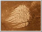
 Dunefield
This image shows several dune types which are found in the north circumpolar dunefield. This thumnail
image shows a section of transverse dunes. The full image has a field of traverse dunes on the left and barchan dunes on the
right with a transition zone inbetween. Transverse dunes are oriented perpendicular to the prevailing wind direction. They
are long and linear, and frequently join their neighbor in a low-angle "Y" junction. Barchan dunes are crescent-shaped mounds
with downwind-pointing horns. These dunes are comparable in size to the largest dunes found on the Earth. (Copyright Calvin
J. Hamilton)
 Local Dust Storm
Local dust storms are relatively common on Mars. They tend to occur in areas of high topographic
and/or high thermal gradients (usually near the polar caps), where surface winds would be strongest. This storm is several
hundreds of kilometers in extent and is located near the edge of the south polar cap. Some local storms grow larger, others
die out. (Copyright Calvin J. Hamilton; caption by LPI)
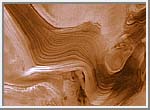
 White Rock
This image shows a lesser known, but unusual feature on Mars. It is commonly called "White Rock".
The white feature is eroded crater fill, but exactly how it was formed has not been satisfactorily explained. White Rock was
not formed by polar processes because it lies near to the equator at latitude -8 degrees and longitude 355 degrees. It has
been modified through aeolian erosion showing transverse and longitudinal erosional features. (Copyright 1998 by Calvin
J. Hamilton)
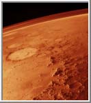 Martian Atmosphere
This oblique image taken by the Viking orbiter spacecraft shows a thin band of the Martian
atmosphere. This image looks northeast across the Argyre basin. The Argyre basin is about 600 kilometers across with a rugged
rim of about 500 kilometers in width. (Copyright 1997 by Calvin J. Hamilton)
----------------------------------------------------------------------------------------------------------------------
Phobos
Phobos (IPA /ˈfoʊbəs/, Greek Φόβος:
"Fright"), is the larger and innermost of Mars' two moons, and is named after Phobos, son of Ares (Mars) from Greek Mythology. Phobos orbits closer to a major planet than any other moon in the solar system, less than 6000 km above the surface of Mars,
and is also one of the smallest known moons in the solar system. Its systematic designation is Mars I. The adjectival form of the name is Phobian, and in fairly common usage.
Discovery

The actual telescope used to discover Phobos
Phobos was discovered by American astronomer Asaph Hall on August 18, 1877 at the US Naval Observatory in Washington, D.C at about 09:14 GMT (contemporary sources, using the pre-1925 astronomical convention that began the day at noon, give the time of discovery
as August 17 16:06 Washington mean time). [1]. Asaph Hall also discovered Deimos, Mars' other moon.
The notebook of the discovery of Phobos by Asaph Hall is as follows:
- "I repeated the examination in the early part of the night of [August] 11th, and again found nothing, but trying again
some hours later I found a faint object on the following side and a little north of the planet. I had barely time to secure
an observation of its position when fog from the River stopped the work. This was at half past two o'clock on the night of
the 11th. Cloudy weather intervened for several days.
- "On 15 August the weather looking more promising, I slept at the Observatory. The sky cleared off with a thunderstorm at 11 o'clock and
the search was resumed. The atmosphere however was in a very bad condition and Mars was so blazing and unsteady that nothing
could be seen of the object, which we now know was at that time so near the planet as to be invisible.
- "On August 16 the object was found again on the following side of the planet, and the observations of that night showed that it was moving
with the planet, and if a satellite, was near one of its elongations. Until this time I had said nothing to anyone at the
Observatory of my search for a satellite of Mars, but on leaving the observatory after these observations of the 16th, at
about three o'clock in the morning, I told my assistant, George Anderson, to whom I had shown the object, that I thought I
had discovered a satellite of Mars. I told him also to keep quiet as I did not wish anything said until the matter was beyond
doubt. He said nothing, but the thing was too good to keep and I let it out myself. On 17 August between one and two o'clock, while I was reducing my observations, Professor Newcomb came into my room to eat his lunch and
I showed him my measures of the faint object near Mars which proved that it was moving with the planet.
- "On August 17 while waiting and watching for the outer moon, the inner one was discovered. The observations of the 17th and 18th put beyond
doubt the character of these objects and the discovery was publicly announced by Admiral Rodgers."
The names were suggested by Henry Madan (1838–1901), Science Master of Eton, from Book XV of the Iliad, where Ares summons Fear and Fright.
Phobos was photographed close-up by Mariner 9 in 1971, Viking 1 in 1977, Phobos 2 in 1988, Mars Global Surveyor in 1998 and 2003, and by Mars Express in 2004 .
Orbital characteristics

Orbits of Phobos and Deimos (to scale), seen from above Mars' north pole
Phobos orbits Mars below the synchronous orbit radius, meaning that it moves around Mars faster than Mars itself rotates.
Therefore it rises in the west, moves comparatively rapidly across the sky (in 4 h 15 min or less) and sets in the east, approximately
twice a day (every 11 h 6 min). It is so close to the surface (in a low-inclination equatorial orbit) that it cannot be seen
above the horizon from latitudes greater than 70.4°.
This low orbit means that Phobos will eventually be destroyed: tidal forces are lowering its orbit, currently at the rate of about 1.8 metres per century, and in about 50 million years it will either
impact the surface of Mars or (more likely) break up into a planetary ring. Given Phobos' irregular shape (intermediate between a prolate and oblate spheroid) and modeling it as a pile of rubble (specifically a Mohr-Coulomb body), it has been calculated that Phobos is stable with respect to tidal forces, but it is estimated that Phobos will pass
the Roche Limit for a rubble pile of its description when its orbital radius drops to about 8400 km, and will probably break up soon afterwards
[2]. Because of its ellipsoidal shape alone, the gravity on Phobos' surface varies by about 210%; the tidal forces
raised by Mars more than double this variation (to about 450%) because they compensate for a little more than half of Phobos'
gravity at its sub- and anti-Mars poles.
As seen from Phobos, Mars would be 6400 times larger and 2500 times brighter than the full Moon as seen from Earth, taking up a full 1/4 of the width of a celestial hemisphere. This means that Phobos would look smaller
than Earth's moon as seen from the planet's surface.
As seen from Mars' equator, Phobos would be one-third the angular diameter of the full Moon as seen from Earth. Observers at higher Martian latitudes (less than the 70.4° latitude of invisibility) would see a smaller angular diameter
because they would be further away from Phobos. Phobos' apparent size would actually vary by up to 45% as it passed overhead,
due to its proximity to Mars' surface. For an equatorial observer, for example, Phobos would be about 0.14° upon rising and
swell to 0.20° by the time it reaches the zenith. By comparison, the Sun would have an apparent size of about 0.35° in the Martian sky.
Phobos' phases, inasmuch as they could be observed from Mars, take 0.3191 days to run their course (Phobos' synodic period), a mere 13 seconds longer than Phobos' sidereal period.
Physical characteristics

A montage of three separate images taken by
Viking 1 on
October 19,
1978. The large crater (mostly in darkness) on the upper left of the image is
Stickney
Phobos is a dark body that appears to be composed of C-type surface materials. It is similar to the C-type (blackish carbonaceous chondrite) asteroids that exist in the outer asteroid belt. Phobos's density is too low to be pure rock, however, and it is probably composed
of a mixture of rock and ice.
The Soviet spacecraft Phobos 2 detected a faint but steady outgassing from Phobos. Unfortunately Phobos 2 failed before it could determine the nature of
the material, but it is most likely water. Recent images from Mars Global Surveyor indicates that Phobos is covered with a layer of fine dust about a metre thick, similar to the regolith on the Earth's Moon.
Phobos is highly nonspherical, with dimensions of 27 × 21.6 × 18.8 km. It is heavily cratered, and the most prominent surface feature is the large crater named Stickney, after the maiden name of Asaph Hall's wife Chloe Angeline Stickney Hall. Like Mimas's crater Herschel on a smaller scale, the impact that created Stickney must have almost shattered Phobos. The grooves and streaks on the surface
were probably also caused by the Stickney impact. The grooves are typically less than 30 m deep, 100 – 200 m wide, and
up to 20 km in length.
Origin
Phobos and Deimos both have much in common with carbonaceous (C-type) asteroids, with very similar spectra, albedo and density to those seen in C-type asteroids. This has led to speculation that both moons could have been captured into Martian orbit
from the main asteroid belt. However, both moons have very circular orbits which lie almost exactly in Mars' equatorial plane, while captured moons would be expected to have eccentric orbits in random inclinations. Some evidence suggests that Mars
was once surrounded by many Phobos- and Deimos-sized bodies, perhaps ejected into orbit around it by a collision with a large
planetesimal [3].
"Hollow Phobos" claims
Around 1958, the distinguished Russian astrophysicist Iosif Samuilovich Shklovsky, studying the secular acceleration of Phobos' orbital motion, suggested a "thin sheet metal" structure for Phobos, a suggestion
which led to speculations on Phobos' artificial origin. Shklovsky based his analysis on estimates of the upper martian atmosphere's
density, and deduced that for the weak braking effect to be able to account for the secular acceleration, Phobos had to be
very light —one calculation yielded a hollow iron sphere 16 km across but less than 6 cm thick.
Competing explanations were based on the land tides Phobos could raise on Mars. The reality of the secular acceleration itself (corresponding to an altitude loss of about 5×10⁻¹²
per revolution, about 5 cm per year) was later subjected to doubt, and the problem vanished on its own by 1969. In a February 1960 letter to the journal Astronautics, however, Siegfried Frederick Singer, then science advisor to President Eisenhower, came out in support of Shklovsky's theory, going as far as stating that "[Phobos'] purpose would probably be to sweep up
radiation in Mars' atmosphere, so that Martians could safely operate around their planet". A few years later, in 1963, Raymond H. Wilson Jr., Chief of Applied Mathematics at NASA, allegedly announced to the Institute of Aerospace Sciences that "Phobos might be a colossal base orbiting Mars", and that NASA itself was considering the possibility.
Similar "hollow Moon" claims occurred at around the same time.
Jonathan Swift's 'prediction'
In part 3 chapter 3 (the "Voyage to Laputa") of Jonathan Swift's famous satire Gulliver's Travels, a fictional work written in 1726, the astronomers of Laputa are described as having discovered two satellites of Mars orbiting at distances of 3 and 5 Martian
diameters, respectively. The actual orbital distances of Phobos and Deimos are 1.4 and 3.5 Martian diameters, respectively.
This is regarded as a fascinating coincidence; no telescope in Swift's day would have been even remotely powerful enough to
discover these satellites.
Phobos in fiction
The first episode of the computer and video game Doom takes place in a UAC base on Phobos.
Phobos also featured in Kim Stanley Robinson's Mars trilogy as having a base built by the first colonists to Mars. Later the moon is overtaken by multinational forces and is de-orbitted by the Martian rebels
---------------------------------------------------------------------------------------------------------------------
Deimos
Deimos (IPA /ˈdaɪməs/ or /ˈdiːməs/;
Greek Δείμος: "Dread"), is the smaller and outermost of Mars’ two moons, named after Deimos from Greek Mythology.
Discovery
Phobos and Deimos were both discovered by American astronomer Asaph Hall. The names were suggested by Henry Madan (1838–1901), Science Master of Eton, from Book XV of the Iliad, where Ares (the Roman god Mars) summons Panic (Deimos) and Fear (Phobos).
Deimos was discovered on August 12, 1877 at about 07:48 UTC (given in contemporary sources as "August 11 14:40" Washington mean time using the old astronomical convention of beginning a day at noon, so 12 hours must be added to get the actual local mean
time). [1] It has been designated Mars II.
Characteristics
Deimos is probably an asteroid that was perturbed by Jupiter into an orbit that allowed it to be captured by Mars, though this hypothesis is still in some dispute. Like most bodies of its size, Deimos
is highly nonspherical with dimensions of 15×12×10 km.
Deimos is composed of carbon-rich rock, much like C-type (carbonaceous chondrite) asteroids, and ice. It is cratered, but the surface is noticeably smoother than that of Phobos, caused by the partial filling of craters with regolith. The two largest craters, Swift and Voltaire, measure about 3 kilometres across.
As seen from Deimos, Mars would be 1000 times larger and 400 times brighter than the full Moon as seen from Earth, taking up a full 1/11 of the width of a celestial hemisphere.
As seen from Mars, Deimos has an angular diameter of no more than 2.5' and would therefore appear starlike to the naked
eye. At its brightest ("full moon") it would be about as bright as Venus is from Earth; at the first or third quarter phase it would be about as bright as Vega. When Deimos passes in front of the Sun its angular diameter is only about 2.5 times the angular diameter for Venus during a transit of Venus from Earth. With a small telescope, a Martian observer could see Deimos' phases, which take 1.2648 days to run their course (Deimos'
synodic period).
Orbits of Phobos and Deimos (to scale)
Unlike Phobos, which orbits so fast that it actually rises in the west and sets in the east, Deimos rises in the east and
sets in the west. However, the orbital period of Deimos of about 30.4 hours exceeds the Martian solar day ("sol") of about 24.7 hours by such a small amount that it takes 2.7 days between rising and setting for an equatorial observer.
Because Deimos' orbit is relatively close to Mars and has only a very small inclination to Mars' equator, it cannot be
seen from Martian latitudes greater than 82.7°.
Deimos in fiction
In part 3 chapter 3 (the "Voyage to Laputa") of Jonathan Swift's famous satire Gulliver's Travels, a fictional work written in 1726, the astronomers of Laputa are described as having discovered two satellites of Mars orbiting at distances of 3 and 5 Martian
diameters, respectively. The actual orbital distances of Phobos and Deimos are 1.4 and 3.5 Martian diameters, respectively.
This is regarded as a fascinating coincidence; no telescope in Swift's day would have been even remotely powerful enough to
discover these satellites.